The Appalachian Trail: Everything You Need to Know
The Appalachian Trail: Everything You Need to Know
The Appalachian Trail runs 2,198 miles from Springer Mountain in Georgia to Mount Katahdin in Maine, passing through 14 states, over 500 peaks, and through the oldest mountain range in North America. It is the world’s most walked long-distance trail — and one of the most humbling.
The Basics
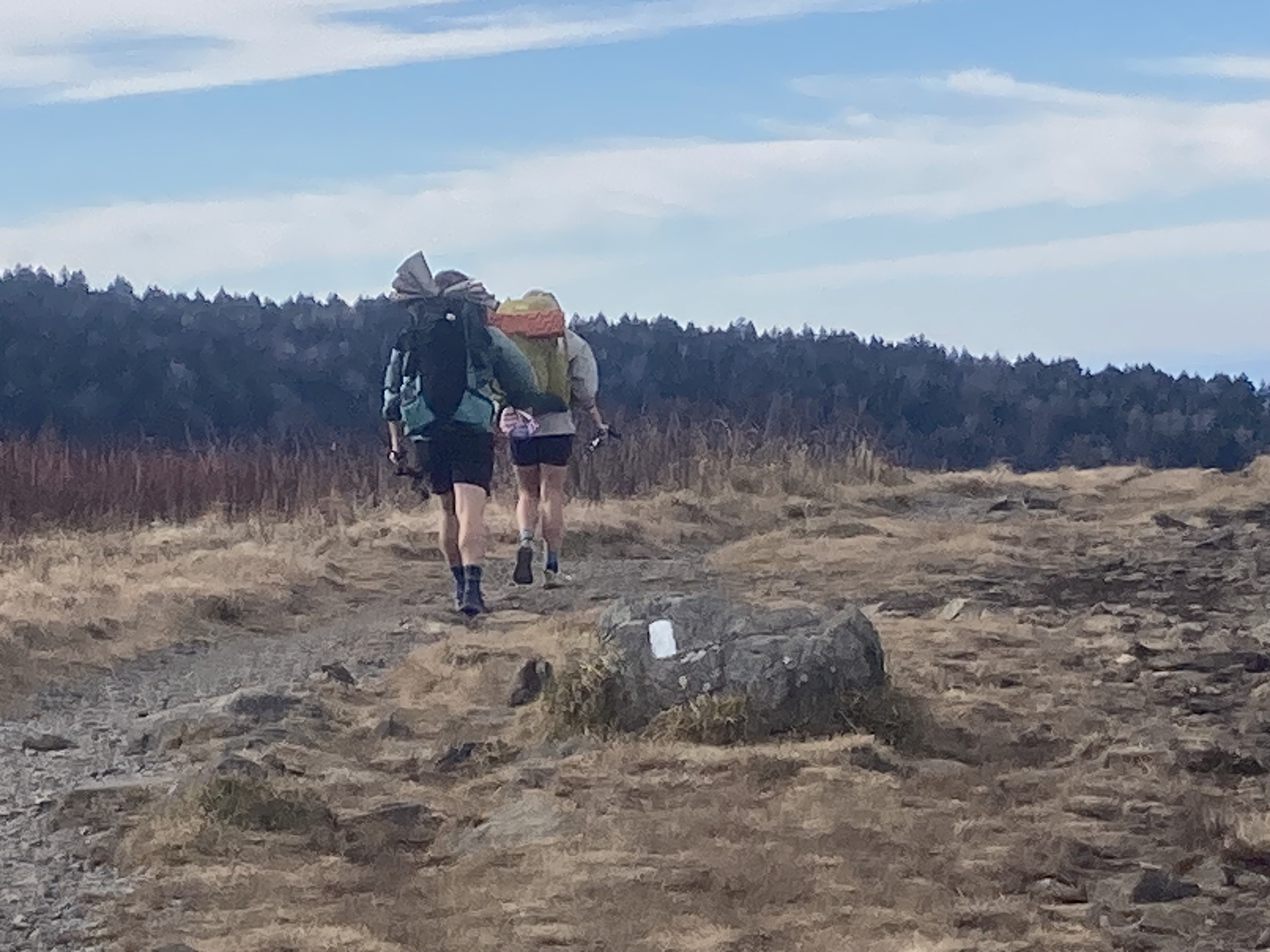
Length: 2,198 miles (exact mileage shifts as the trail is rerouted) States: Georgia, North Carolina, Tennessee, Virginia, West Virginia, Maryland, Pennsylvania, New Jersey, New York, Connecticut, Massachusetts, Vermont, New Hampshire, Maine Shelters: ~260 three-sided lean-tos, spaced roughly every 8–12 miles Thru-hike time: 5–7 months for most hikers White blaze: White rectangular blazes on trees and rocks mark the entire route. Blue blazes indicate side trails to shelters, water, and towns.
Directions: NOBO, SOBO, or Section?
Northbound (NOBO): The most popular approach. Start at Springer Mountain, GA between mid-February and mid-April. Arrive at Katahdin before mid-October when Baxter State Park closes for the season. The majority of thru-hikers go NOBO, which means you’ll have company — the AT “bubble” is a real community of hikers moving north together.
Southbound (SOBO): Start at Katahdin in June, after the park opens, and hike to Georgia. You’ll enter the White Mountains and southern Maine first, when you’re least experienced — a harder choice, but a more solitary experience.
Section hiking: You don’t have to do the whole thing at once. Many “2,000-milers” complete the AT over years or decades, knocking off a state or a stretch each season. The AT Conservancy tracks and awards your completion.
The Highlights
Smoky Mountains, TN/NC (miles 165–233): Old-growth forest, dramatic ridgeline walking, historic shelters with bear cables, and often enough crowds in season (a permit and shelter reservation is now required to camp within the Smokies). Clingmans Dome — the highest point on the entire AT at 6,643 feet — is here.
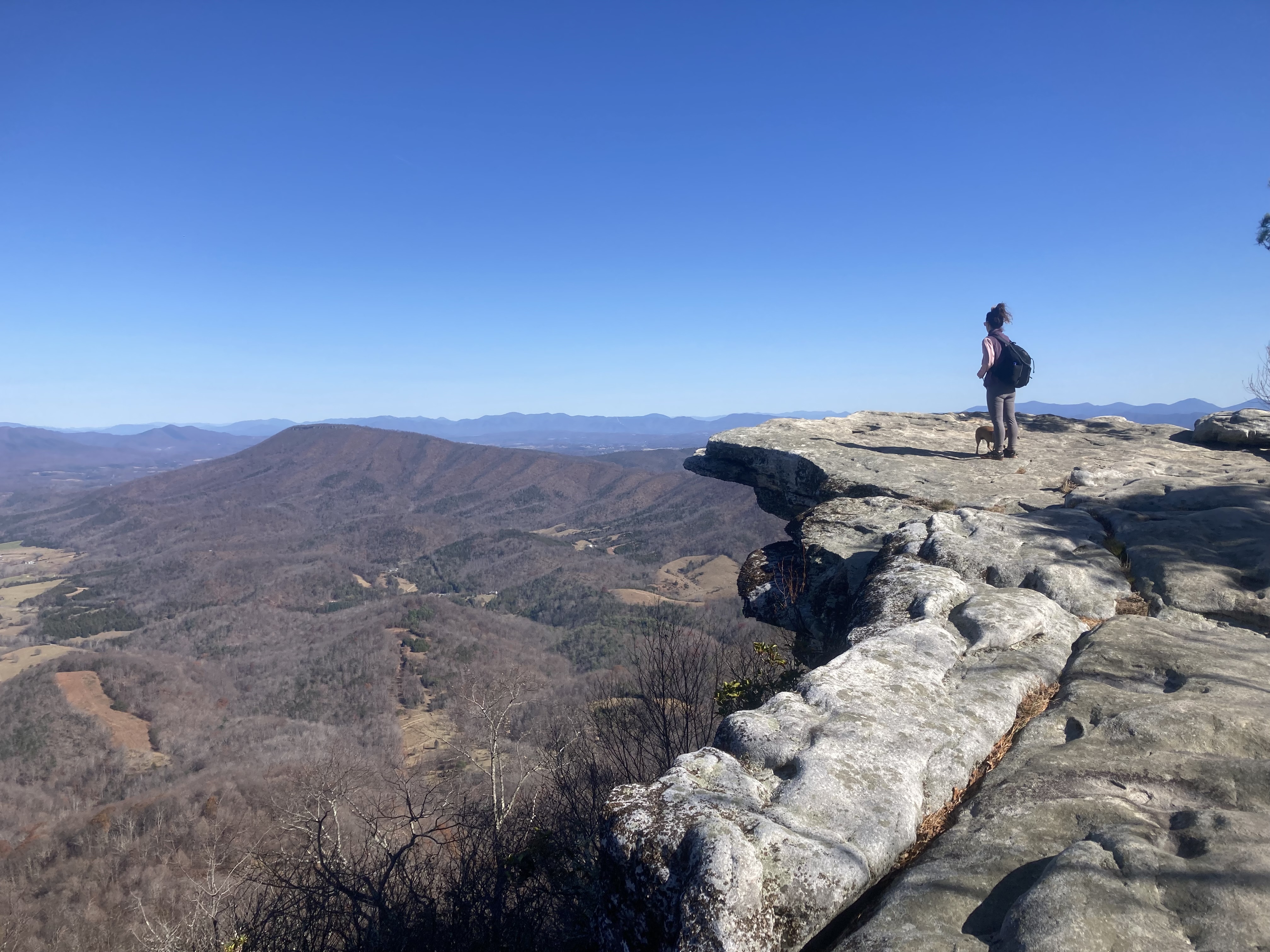
Roanoke Triple Crown, VA (miles ~700–730): Dragon’s Tooth, McAfee Knob, and Tinker Cliffs — the three most iconic day hikes on the AT in Virginia, all within a 20-mile stretch above Roanoke. McAfee Knob is the single most-photographed point on the entire trail. The RATC (Roanoke Appalachian Trail Club) maintains this section and runs 100+ organized hikes per year. Read the full Triple Crown guide →
Shenandoah National Park, VA (miles 866–1,005): 107 miles of ridgeline walking with Skyline Drive paralleling the trail. Wayside lodges sell hot food and cold drinks. Black bears are plentiful.
Pennsylvania rocks: Every AT thru-hiker knows about Pennsylvania’s rocks — miles of ankle-twisting talus that chews through boot soles. Beloved in memory, not in the moment.
The White Mountains, NH (miles 1,784–1,902): The trail’s most technical stretch. Above treeline for miles, exposed ridgelines, the Presidential Range. Mt. Washington can see 100+ mph winds any month of the year. Huts operated by the AMC (Appalachian Mountain Club) offer meals and bunks.
100-Mile Wilderness, ME (miles 2,078–2,178): The final stretch before Katahdin — 100 miles with no road crossings and no resupply. Hikers carry everything. The trail ends at Katahdin’s Baxter Peak — a full-day ascent on its own.
The Shelters
About 260 three-sided wooden lean-tos line the AT, each with tent sites, a water source nearby, and usually a privy. Staying in shelters is free; tent sites near shelters are free. Camping outside the shelter system varies by state and land management area. Water sources are generally plentiful but should always be filtered. Shelter registers (paper notebooks) record who’s been through — reading them is half the entertainment of an AT hike.
Trail Communities
The AT passes near or through dozens of towns — some of which have built entire economies around supporting hikers. Damascus, VA (Trail Days festival each May); Hot Springs, NC; Harpers Ferry, WV (ATC headquarters); Hanover, NH (Dartmouth College); Millinocket, ME (the final outfitter town before Katahdin). These “trail towns” offer resupply, laundry, showers, and the particular warmth communities reserve for people walking past on a long journey.
Permits and Fees
Most of the AT is free and permit-free. Exceptions:
- Great Smoky Mountains NP: A camping permit and shelter reservations are required for any overnight stay within the park. Day hiking is free.
- Baxter State Park (Katahdin): Reservations required for day hikes to Katahdin; day-use capacity is limited. Apply early.
- Shenandoah NP: Camping in the backcountry requires a free permit.
The ATC (appalachiantrail.org) maintains a register and asks thru-hikers to register their attempt — it helps with trail management and emergency response.
Planning a section hike? Free dispersed camping is available throughout the national forest land that borders much of the AT corridor — Virginia, North Carolina, Tennessee, West Virginia, and New Hampshire all have extensive national forest free camping a short walk off the trail.
The AT vs. the PCT
People who’ve done both tend to describe the AT as a people trail and the PCT as a scenery trail — a generalization but not an inaccurate one. The AT passes through towns, over roads, and through the communities of the eastern US in ways the PCT doesn’t. The social experience on the AT is a bigger part of why people do it.
Both are worth it. Most long-trail hikers eventually do both.
Southern terminus: 34.6267°N, 84.1937°W | Springer Mountain, GA